heather hikes
  • LIfe on the trail
  • Home
  • About
  • Cool Causes
  • Where I am now
  • Milage

September Stats

10/14/2013

0 Comments

 
Average Daily Miles: 13.1
Total Miles in Sept 184
Number of Over 20 Mile Days: 1
Number of Zero Days: 1
Number of Days I wanted to Just Quit: 1
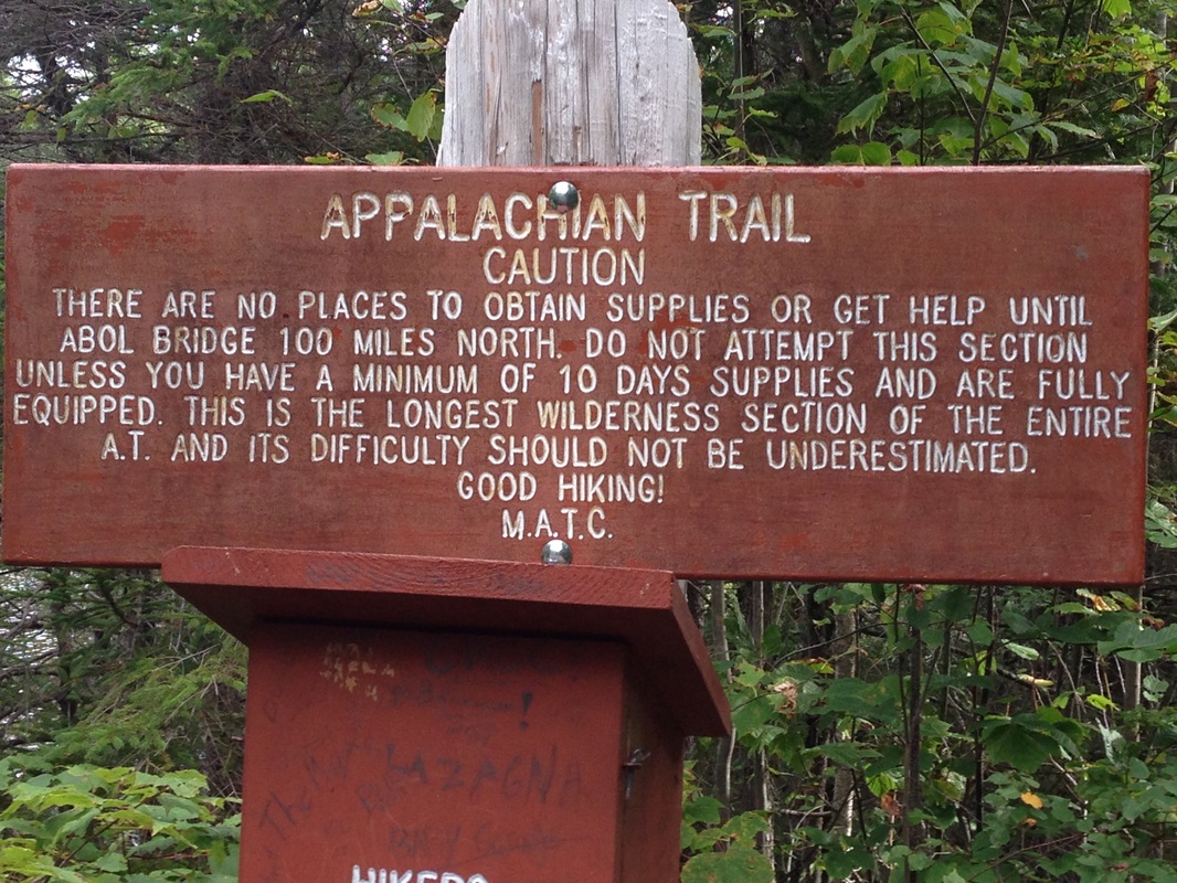
Gear Destroyed by Maine: Just about all of it
Number of Times Maine Tried to Kill Me: too many to count
Number of Days I Killed It in Maine: all to them
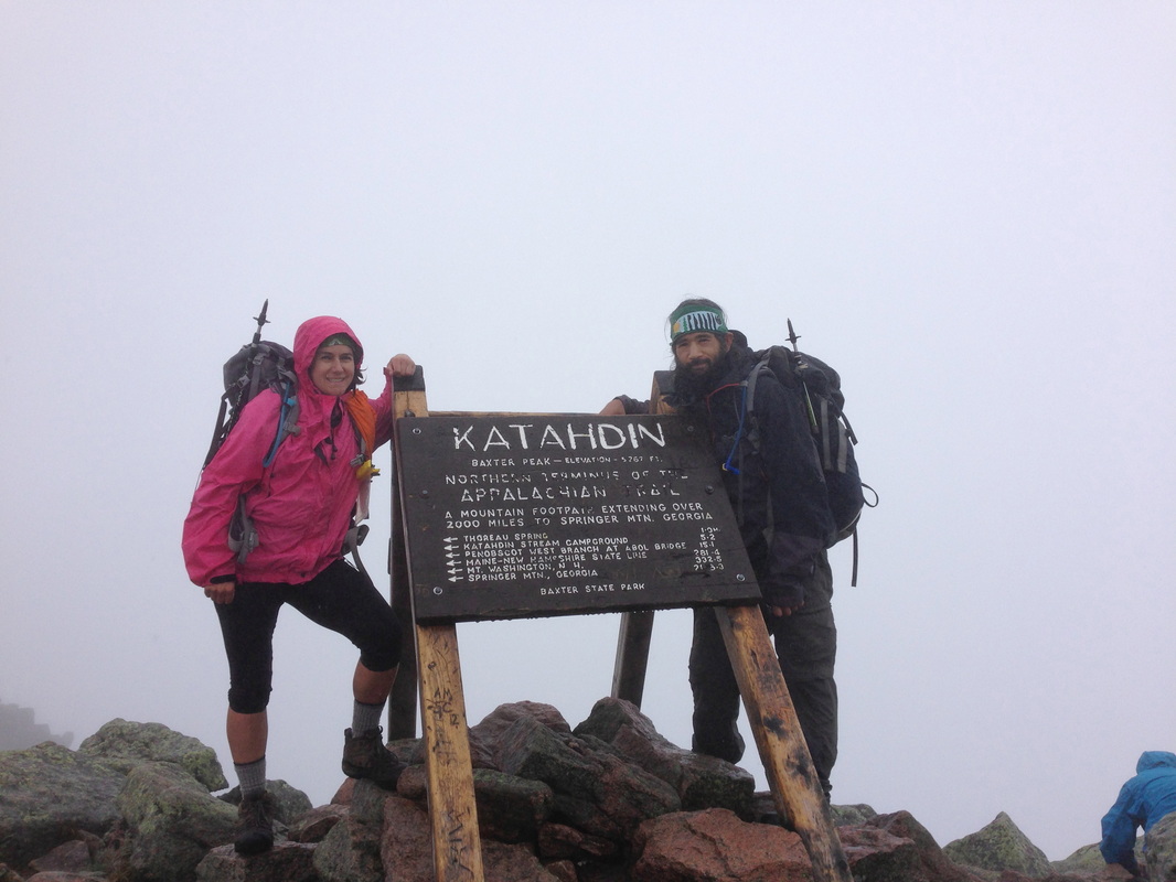
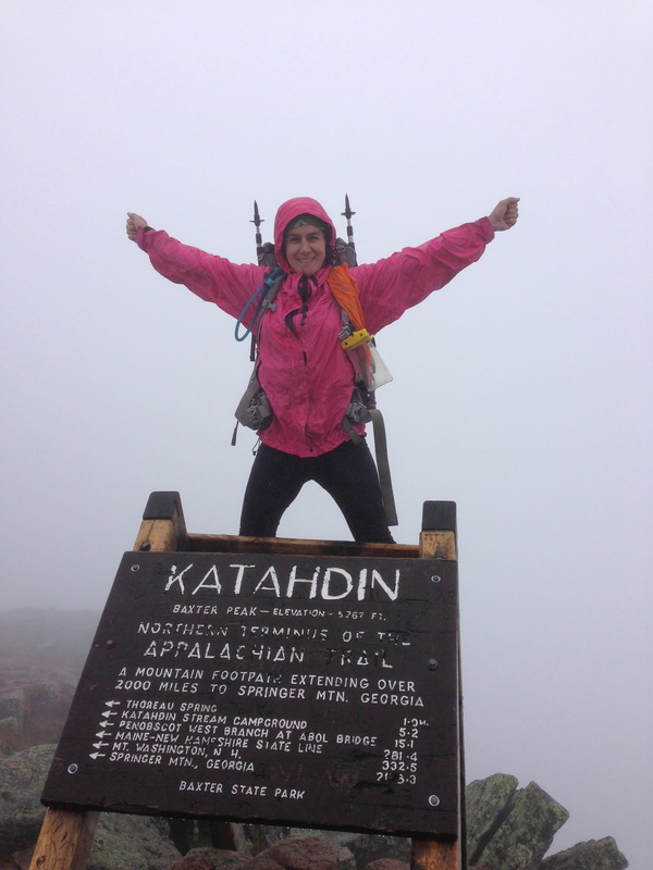
How Happy I am that I Did this Thru-HIke: too much to express!
0 Comments

The Journey Ends

10/13/2013

1 Comment

 
September 14: We awake and pack up early, leaving the hotel at 5:30 to head up to Baxter State Park. We do not have a park pass, so my Dad will drop us off at the entrance and we will hitch to the trailhead. Walking past the entrance gate, we are questioned by the ranger "Where are you headed today?" He says he will ask passing motorists if they would be willing to give us a ride as they check in. About 15 minutes later, a prius pulls over and Sarah gives us a ride. Sarah is from New Hampshire, an avid hiker, going to attempt knife edge today. We thank her as we pull into the already near full parking lot at The Birches Campsite. 

First order of business: go to the ranger station to check in. He gives us a number: Subaru and I are thru-hikers 406 and 407 this year. Looks like the weather could go either way today. There is a bit of cloud cover at the summit now; that could burn off in the late morning or stick around and generate precipitation. I guess we'll see. 

We hit Katahdin Stream Trail a little after 7 am. The first mile or so is fairly easy; mild climb, mild rocks, mild roots. We cross a bridge, see that last privy on the trail (and I don't have to use it. *sigh*), and then the trail turns to follow alongside Katahdin Stream. We pass some pretty waterfalls, stop to take some pictures. We are leap frogging with a couple groups of day hikers, falling ahead or behind whenever we stop to take photos or have a snack.
Picture
KATAHDIN SUMMIT AS SEEN FROM THE BIRCHES CAMPSITE
Picture
Picture
After the falls, the trail gets decidedly steeper and rockier. In many spots, there are side trails through the trees to avoid a particularly steep or hard climb. I'm not ashamed to say I took advantage of the trails. The trail itself has now merged with Katahdin Stream; we are essentially walking in a stream bed, rock hopping and grabbing onto trees for balance. (I'm still of the mindset to keep my feet dry for as long as possible. Lt. Dan says so!) 

Once we emerge above treeline, we see near vertical rock faces with meandering white blazes. This is not going to be an easy climb! We scramble up rock faces, hand over hand with our poles tucked in the packs. Sometimes it takes a few minutes of searching to see exactly what the intended route is; sometimes it looks near impossible until you look a little further to the right and --behold!-- a white blaze next to a crevasse that looks do-able. 

We come to a section with a rebar handle built into the rock. The rebar is so far above my head, I need to step up onto a rock in a crack in the rock face in order to stand of tip-toes to barely grasp the rebar with my arms overhead. I have no idea how I'm going to get up. I back off, let Subaru go first. He grasps the  rebar, doe a semi-chin up, and puts his foot up to shoulder level to place it on another small nub or rebar. From here, he is able to muscle up to the next level of rock face. Now it's my turn. It climb back up on the rock in the crack, stretch to grab the rebar, and place my other foot on the rock wall. By pushing backward, I'm able to lift my left foot off the rock, wedge it back into the crack a few feet higher, and then lift my right foot up to head level where I place it on the rebar nub. Now, between my hands on the rebar, my right foot on the rebar, and my left foot, which I have inched up the crack another foot or so, I can heave myself up, like performing a kip maneuver on the bars in gymnastics. I scramble up onto the rocks hands and knees, wondering how the heck I'm going to get back down.

The trail continues in this way, rock scrambles, crawling on my belly, grabbing onto rebar, searching for white blazes. The cloud cover continues, the temperature is in the low 60s. It's good weather for hiking. Not hot, but not wet, either. 

After continuing in this fashion for 2 miles or so, we come to The Gateway: the terrain levels off and we once again are rock hopping through a stream bed. The clouds have gotten thicker here and we find ourselves in a dense fog, bordering on a light rain. We take out our rain jackets and continue on. 

The last mile was not steep. It was not difficult. It was not treacherous. But it was long. We kept thinking "Oh, right over this ridge!" only to see another ridge ahead. Isn't that always the way? But gradually, eventually, finally, we saw that iconic sign marking the summit of Katahdin; the end of the Appalachian Trail.  
Picture
Picture
Picture
I don't know what I expected to feel at the end of the journey: elation? A sense of pride? Enlightenment? All I felt was tired. I'd never been so tired in my life. And hungry. I wanted to eat. So after the pictures at the sign, we did what we do best: we opened our packs and had ourselves a nice lunch in the fog. 

Of course, we still had to get down. 

I'm happy to report that unlike every other mountain on the trail, the descent from Katahdin was actually easier than the climb. It took just as long, but it wasn't as taxing. That rebar section? Way easier going down. Those sections where I cut through the trees on the way up? Could totally scramble down. I was using my arms just as much -- no, more -- than my legs. But it felt good. I felt strong. On the way down, I felt like I had accomplished something.

When we once again reached The Birches Campground, we were pleased to see that Funkytown had arrived! They were having a big cookout and invited us to come over and get some sausages and beer. They were going to summit tomorrow and guess who else? Roadrunner! He ended up at the campground one day after us. So we took a little time to hang out and eat and trade trail stories. 
Picture
And guess who finished hiking shortly after we did? Sarah! She gave us a ride back to the gate, where my Dad was waiting in the car.

Back in Millenocket, we went to the cafe to sign the ceiling tile, grabbed some food to go, and hit the road for Massachusetts. 

Mission accomplished!
1 Comment

The Last Zero Day

10/11/2013

0 Comments

 
September 13: Our unplanned, but totally needed zero day. We slept in until 7am and took the oh-so-nice morning shower. Then we went downstairs to eat breakfast. At breakfast, we saw Professor, Peaches, Mother Teresa. We saw Whistler and Strawberry Donut, who we hadn't seen since Pennsylvania. They summited on Sept 12 and were looking forward to buying new clothes before their flight back to Germany. The bunch of us were talking with some other hotel guests who had never heard of thru-hiking. We were like a bunch of celebrities. 

After breakfast, we walked over to Baxter State Park Headquarters to see about getting parking permits for tomorrow, but found that they were all gone. Between the weekend and the festival this weekend (End of Trail Days) the park had reached its limit. We would have to get dropped off at the entrance and hitch to the trail head. 

Then we took some time to clean our gear, throw away things we didn't need any more (it seemed so wrong to throw away zip lock bags that we could rinse out and use for a couple more weeks!) and get slack packs ready for tomorrow. And check to see if our tents were dry.

We went over to the Appalachian Cafe for lunch, where we bumped into Barbarosa, Dip-n-Sip, and Newton. There was a ceiling tile that you could sign if you had complete your thru-hike. We figured we'd sign it now when we had time so we could head home sooner tomorrow. No dice. They would not let us sign until we had touched that Katahdin sign. The cafe also had a sundae for sale: Summit Sundae -- 14 scoops of ice cream (one scoop for every state in the AT), hot fudge, whipped cream, sprinkles, a banana, M&Ms, a snickers bar, and a donut. I didn't even think about attempting it.

Back at the hotel, we made use of the hot tub and stretched our sore muscles out before going back upstairs for a nap. Dinner was at a closer restaurant and to bed early for an early start tomorrow.
Picture
Picture
Picture
0 Comments

Out of the Wilderness

10/10/2013

1 Comment

 
September 12: Wake up to rain. Since we have a shorter day today, we decide to sleep in one more hour in hopes that the rain will stop. (Always funny to talk from different tents, yelling back and forth) We were lucky this morning; it did stop raining.

We got up, packed up our wet tents, ate, and hit the trail. Though it had stopped raining, there was still water dripping from the trees, so I had a chance to try out my home made pack cover. Worked very well, but was very hot against my back! We got water at the spring next to the lake, enjoying the beautiful early morning sunshine on the water.

The last 10 miles of the 100 mile wilderness did not let up. We really had to work for every mile. It wasn't steep, there were no big climbs. But the roots! Man did we have roots to negotiate. So many times during the day, I thought "Really? This is the best we can do for trail maintenance?" 

A few weeks back, we had been hiking with Kokopelli, a hiker who attempted a thru-hike in 2012, but got injured 50 miles before Katahdin. I can totally see how that would happen. It's like somebody in charge of trail maintenance is TRYING to injure people!

See what I mean?

Picture
Picture
Of course, there was mud, as well.
Picture
MId morning, I felt something hit me in the ear. Hard. I turned around, trying to figure out what had just happened, when I was hit in the head again. By a pinecone. That had been thrown by a red tailed squirrel up in a tree. A squirrel just threw a pinecone at me! 

Subaru came walking up and said "Did a squirrel just throw a pine cone at you?"

Yes. Yes he did. And now he's scuttling down the tree trunk, chattering at me in an angry fashion.

"Okay!" I yelled. "I'm going! I'm going!" And then I impaled him with my trekking pole and killed him.

Just kidding. I turned around and walked away.

It's not enough that Maine has tried to kill me with its rocks and its roots and its crevices and its steep inclines and even steeper descents, its streams to ford and to rock hop over on slippery, slippery rocks, with its ledges and loose gravel. No, now Maine is sending squirrels after me. Thank God I'm getting out of the wilderness today!

We stopped for a break at the shelter, a mere 7 miles from our campsite. It had taken us twice as long to get here as we expected it to. And right before the shelter, we had this stream to cross:


Picture
Eventually, we reached the warning sign on the north boundary of the 100 mile wilderness. We were out! A little bit more to the road, and then .5 miles to Abol Bridge. Abol Bridge has a gorgeous view of Katahdin, but unfortunately, we were enveloped in threatening looking clouds; no view for us.

Luckily for us, we reached the store moments before the clouds opened up and the downpour started. My dad had reached the store about 10 minutes before we did. So at least our timing was good. We got in the car and headed toward Millenocket for a shower and some food.

Originally, we had planned on summiting on September 13. But we were both completely exhausted. I felt like I was all ribs and clavicle; Subaru looked like a scarecrow. We decided to take a zero day and rest up for the summit.
1 Comment

I've Had It!

10/9/2013

1 Comment

 
September 11: Today was the day Maine did me in. Today was the day I just wanted to end this stupidity and  go home. Today was the day I'd had it.

Maybe it was because yesterday had been so flat and easy. I really thought it was going to be easy until we reached Katahdin. I never should have fallen for it. Maine does that; the bait and switch. And I had fallen for it once again.

It began in the morning when I got my period early. Not that THAT was Maine's fault. But being out in the woods at that time is just not the most comfortable thing in the world.

The day started out mildly enough. It was flat, but boggy en route to Nahmakanta Stream Campsite, our original destination for yesterday. We rock hopped across a river crossing and up a metal ladder. Then things got really muddy. 

While walking across a bog bridge, I slipped on the wet wood and fell with my right foot in the mud, up past my boot. The mud was like quicksand; it took me about 90 seconds of wiggling my leg back and forth to overcome the suction and pull my leg *pop* out of the mud. 

So now my right foot was ensconced in a ball of mud; down my boot, up my shin, all around my boot and in the treads. I made it a point to slow down over the bog bridges, especially now that my right foot was all the more slippery from the mud.

A while later, we were crossing another mud pit, this one without the benefit of a bog bridge. We had to rock hop. I took it slow and easy, testing the rocks carefully. Which worked well. Until I came to a rock that was just a little more slanted than the others. My slippery right foot slipped right off the slanted surface and I landed, luckily not in the mud, but on the rock, right on my butt. With my left foot buried in the mud up to mid shin.

Once again, it took a lot of rocking and wiggling to get my leg out, and I needed Subaru to lend a hand for some leverage.  So now both feet resembled muddy soccer balls. Great.

We stopped for some food and I took the opportunity to bang out my boots, wring out my socks, and wipe off my legs. An older couple passed us by, telling us about the rocky, rooty, roller coaster-y day ahead of us. Great.

A few miles later on, as the temperatures climbed into the low 80's, we passed by Nahamakanta Lake and a sandy beach. "Let's jump in." I said. So we were able to rinse off our muddy legs and arms and let our wet socks and boots dry in the sun. It was nice.

I'm so glad we took that dip in the lake. It was a nice bright spot in an otherwise arduous day.

We pushed past Wadleigh Stream Lean To where the rest of the crew was eating and began the climb up Nesuntabunt Mountain. The climb was only 750 feet in absolute elevation gain. But the trail was so disarmingly windy and indirect, that by the time we reached the summit, we had climbed probably 1500 feet to go 750. "Are you kidding me?" we said at the top. And we had another snack.

The descent was more of the same. In order to go down, we went up. And we once again we went down about 1400 feet do descend 750 feet. Stupid Maine!

We then crossed a gravel road,where we saw Grizzly's brother who was picking up the rest of the crew to head to Millenocket for the night. Subaru and I were pushing on. We continued to climb along the roots, the rocks, the relentless ups and downs. I ran out of water 1 mile before Pollywog Stream, as we did not find the previous water source. I got a couple sips from Subaru's bottle and then put the ipod on to distract myself for the mile to the stream. Axl Rose makes everything go a little faster!

After getting some water at the stream, we crossed another road and then started a rocky climb to Rainbow Stream Lean To. The lean to was rather dreary and wet, with a "baseball bat" sleeping platform (made of small diameter logs so it was uneven instead of flat). Once again, we stopped for a break but didn't stay.

After the tricky crossing on a log of Rainbow Stream, we continued along the river for 4 miles. We could hear thunder rumbling in the distance. Oh, great. Now, we were going to get rained on! We hurried along, trying to beat the rain. I slipped on a root at the top of a hill and slid to the bottom of the hill on my butt.

"That's it!" I screamed. "I'm so sick of this stupid trail! I've had it. I want to punch this stupid trail right in the face!"

Now, despite what Subaru may tell you, I did not have outbursts like that on a daily basis. Generally only one breakdown a month or so. And never to the extreme of today's outburst. I mean, I just said I wanted to punch the trail in the face!

But this time, rather than reprimanding me to calm down, Subaru just turned to me with tired eyes and said. "I know. I was thinking the exact same thing." Then turned and kept walking.

In actuality, I didn't really know where the trail's face even was to punch it. Probably at the summit of Katahdin. So I just had to keep going.

Luckily, we reached Rainbow Lake Campsite without rain. We got our tents set up, got some water, and headed down to the lake for a much deserved swim and wash up. We had dinner before it got dark, and all snuggled in our tents before the skies opened up at night. Fell asleep to the sound of rain on the tent and loons calling over the lake. 

I was so ready to be done.
Picture
Picture
Picture
Picture
Picture
1 Comment

The Food Drop

10/9/2013

0 Comments

 
September 10: Up and out today by 7; en route to Jo-Mary Road, where we would be meeting buddy at 9:00 for a food drop. The trail was ridiculously flat and easy. It seemed like were past the hard stuff and it would be smooth sailing from here on out. We made it 6.7 miles in two hours.

Wilson was already at the road, anxiously waiting for the resupply so he could get going with his fast paced schedule. Unfortunately, Buddy wasn't there. We found some nice spots in the sun to relax in and ate some extra food we had in the packs -- a ramen noodle second breakfast! By 10, when Buddy still hadn't arrived, we put a call in and found out that he had an emergency pop up and would be arriving closer to 11. So much for big miles today. We pulled out our pads and napped for an hour. 

When Buddy did show up, he also had spring water to refill and chocolates. So that was good. It also worked out well, as another hiker arrived at the road, lamenting that he had run out of food. So once we got our drop off bags, the food-less hiker jumped in Buddy's van and headed out to Millenocket.

Now loaded down with food, but on flat terrain, we took off at a fast pace, burning up the trail. We reached Potaywadjo Spring Lean To around 2 and went inside for lunch just as it started sprinkling. Shortly thereafter, Professor, Peaches, Grizzly, and Mother Teresa showed up. Everyone was talking about the weather reports they had gotten on their cell phones, calling for an 80% chance of rain overnight. Not wanting to carry wet tents, we waffled back and forth about staying (even though it was really too early to end the day) and going but risking the rain and carrying a wet tent. 

In the end, we all decided to stay in the shelter, even though the sprinkling had long since stopped. Around 5, Mama Goose showed up, as well as Moose, Grazelle, and Brohawk. It was a fun, festive feeling evening, like the full shelters in our hiker bubble back in Virginia. All in bed by 7, listening for the rain that never did come.
0 Comments

The First View of Big K

10/8/2013

4 Comments

 
September 9: Woke up to a cold, cold morning. It had been a great night for sleeping-- cold temperatures, warm sleeping bag, and the sound of a babbling brook. But the morning was very cold. Started the day, once again, in long tights, a thermal top, and gloves. On the trail by 6:30, walking up to Newhall Lean-To in the wind. The ascent was gradual, some rock steps and roots to contend with. As we passed the shelter, we saw Wilson coming out of the side trail to begin his day. So he did make his 18 miles yesterday! 

The morning continued with a pattern of cold and windy at the summit, warmer as we dropped out of the wind. Since we went up and over a series of summits today (Gulf Hagas Mountain, West Peak, Hay Mountain, White Cap Mountain) the pattern became predicable. We played leap frog back and forth with Rosie and Flo, and Jabba, three hikers involved in the Walking Off the War program. Once past Hay Mountain, we seemed to lose the wind and find the sun, making White Cap Mountain more pleasant.

En route to White Cap, we passed a rock on the trail marked with a "K" and an arrow next to it. The ridge runner yesterday had told us to keep and eye out for this rock. We looked up in the direction of the arrow, and there was our first view of Katahdin!

Picture
Picture
Up on top of White Cap Mountain, we had not only fantastic views, but cell phone reception, too, so I could text my Dad about our estimated arrival in Millenocket. 
Picture
LOOKING AT HOW FAR WE'VE COME

Picture
AND HOW FAR WE HAVE LEFT TO GO.

The descent from White Cap Mountain was a nice departure from the descents of yesterday. We had a couple big step downs and some roots, but nothing that made me wonder where the heck the trail went. By the time we reached Logan Brook Lean-To for second lunch, we were strolling along a forest path.

Second lunch was shared with Flo, Rosie, and Jabba. It was a gorgeous spot; Logan Brook almost looked like it had been designed by some designers for a movie. Though it did have the most disgusting privy on the entire trail! (It was almost as dirty as the Doyle Hotel!)

After second lunch, we continued with some more level, mellow walking. With the exception of one small section that had been re-routed due to property line disputes, the trail also looked like it had been designed for a movie set. We continued on, looking for our destination, a sandy beach at Crawford Lake. In true AT fashion, we went down to the lake, then made a hairpin turn and walked back up a ledge to a rocky overlook, down back toward the lake, away from the lake through the forest, and finally, back down to the lake to find the sandy beach. i should be used to this nonsense by now, but when you are SOOO close to your destination for the night, this kind of meandering can really get on your nerves.

Fortunately, our camp spot made all the pointless meandering worth it! A perfect flat area for tenting, a gorgeous lake, nice temps, and a good water source. We went for a nice dip/ bath before dinner, We had a nice leisurely dinner and watched the sun set.

Picture
VIEW OF KATAHDIN ON DESCENT FROM WHITE CAP MOUNTAIN
Picture
Picture
4 Comments

Another Hard Day

10/6/2013

0 Comments

 
September 8: Up especially early today, getting ready in the dark while trying not to wake anyone up. On the trail by 6:30. As I was getting ready, looking at the sky and pondering the possibility of rain, I realized that I had lost my pack cover! (probably got left behind when we were changing rooms in Monson) So before we headed out, I pulled out the scissors on my swiss army knife and improvised a pack cover from a trash bag I had in my pack. 

The day started with a slow climb. Slow going, but not overly difficult. We were passed by Wilson, who was on a mission to get 18 miles in today. We caught up with him at the bald ledges and we all took some time to enjoy the view.
Picture
After the ledges, the climb became very slow and arduous. It took us almost 3 hours to go 4.4 miles to the Cloud Pond Lean-To. Subaru and I had been thinking of trying to get here yesterday. We never would have made it! 

The weather was very strange today: cold, cloudy, and almost rainy at the summit then summer lower down. We stopped for a bit to eat on some rocks in a sunny spot and were passed by the Professor, Mother Teresa, and Grizzly. Then we passed them later on as we were walking on a board walk toward Forth Mountain Bog. Max, the dog from the shelter last night, appeared behind us and started to follow us, but decided he wanted to stay with the others as we passed them (they had food). I assumed that his owner, Eugene, was close behind him. We would later learn that he was, in fact, not.

After the bog, the trail got very rock and very difficult. Everyone was frustrated by the slow progress. Once again, we were leap-frogged by the others in our hiking group as I was trying to send a text message on the summit of Forth Mountain. Going down Forth Mountain was exceedingly difficult. Very rocky, very steep, very narrow trail. And it was then that Eugene arrived practically running with his gigantic backpack, yelling for Max and asking if we had seen him. We told him that Max had followed the other hikers and I said we would step to the side and let him pass when we found a safe spot. Then we started down the rocks. Clearly not wanting to wait and totally lacking in trail etiquette, Eugene pushed by me on the narrow, steep, rocky descent with his gigantic backpack and almost knocked me head over heels down the path. Luckily, I had my poles firmly planted and my Subaru in front of me and on alert. Nobody was hurt. But I was plenty pissed. I mean, when did Eugene get in cahoots with Maine in the plot to kill me?
Picture
Picture
On top of Third Mountain, there are great views, but it's really windy. Too windy to linger too long, so we moved right along. Once again, we leap frog past the rest of the gang. The trail deteriorated sharply on the descent, resembling a landslide more than a trail. At one point, convinced we had taken a wrong turn, Subaru and I spent about 15 minutes trying to find a white blaze. And yes, we were on the correct path, it just didn't seem like it could possibly be right.

We stopped at Chairback Lean-To for second lunch and were confronted by Eugene and Max and another dog owner even crazier than him. Between the two people and the two canines, they were monopolizing 100% of an 8 person shelter. Sub and I were trying to get inside to eat since it by now had started to rain. Neither of the humans seemed to think they should move themselves, their stuff, or their dogs to let us in out of the rain. Finally, I just took matters into my own hands and stepped all over their stuff while pushing my way into the shelter. Not to be a jerk, but I had lost my pack cover and I hadn't practiced putting my trash bag cover on yet.


Picture
The descent from Chairback Mountain was even worse than the descent form Third Mountain! It was like Mahoosuc Notch on a steep angle. Finally, things flattened out as we approached a Pleasant River, a wide ford we had to cross. I had been nervous about this river ford, as the guide book described it as deep, swift moving, slick bottomed, and cold. However, it turned out to be the easiest ford thus far -- ankle deep and not too cold!

We spoke to to a ridge runner who told us there were some good stealth camping sites further up trail, but there was no camping for the next two miles, since it was an old growth forest. He also reassured us that the previous 10 mile were the hardest part of the 100 mile wilderness. Thank goodness!

We pushed on another 3 or so miles and found a beautiful camp spot next to a babbling brook. Ate some dinner and fell into a well deserved sleep as the temperatures dropped for a cold night. 
0 Comments

Slacking Again

10/5/2013

0 Comments

 
September 7: In the morning, we went down for the famous Shaw's all-you-can-eat breakfast. They serve you eggs, sausage, toast, and pancakes. You can have a once around (one of everything) twice around (two of everything) three around, etc. I opted for three around. No problem finishing!

After breakfast, we had a lot of organizing to do. We had slack pack bags, day pack bags, and food drop bags to label and drop off in the correct spots. Luckily, I'm a highly organized person! We got all our perspective bags in their proper places and got in the van to the trail head. 

I'll say this: I am so glad we slackpacked today! Cause once again, the book was quite deceiving in its depiction of flat terrain. It was like New York. On steroids. (That's known as Maine) Lots of little ups and downs, relentlessly. Plus three river fords. On one ford, there was a rope that you could hold onto overhead as you walked across. The current was quite strong, so it was necessary to really hold tight. However, the rope was just a little to high for me, and my arms were overhead, as high as I could get, with just the tips of my toes barely touching the riverbed. I had to have Sub pull the rope down for me! 

It was nice to be part of a group, once again, though. Professor, Peaches, Wilson, Mother Teresa, and Grizzly were nice to eat with, talk with, laugh with. We had first lunch near a nice waterfall, and had some mini food breaks after each river crossing.

After the third river crossing, we followed a side trail marked with pink tape to get our slack pack bags. Oh, so heavy! Just another .7 miles to the shelter. Subaru and I had talked about moving on past the shelter, but by the time we got there, it was 5:15. And we were tired. And then it started raining. So it was good that we stopped.

There was one guy in the shelter when we arrived, he had taken up half of the 6 person shelter for himself and his dog. He was a little taken back when we asked him to move his stuff to the side so we could sleep in the shelter. He was even more taken back when Wilson moved his dog's sleeping pad from the platform to the floor of the shelter. Did he really expect that we would go set up tents out in the rain so that his dog could sleep on the sleeping platform of the shelter? Yes, he did. Oh well.


Picture
0 Comments

Into Monson

10/5/2013

0 Comments

 
September 6: Woke up after a 12 hour sleep to a cold, cold morning! Frozen fingers putting the tent away, jacket and hat on while eating breakfast. I started hiking in long tights, a thermal shirt, and gloves for my cold fingers. 

The day started with a 200 foot climb, which warmed things up a bit. Off came the gloves and the thermal. We continued some gentle, graded walking along the Maine ponds and lakes. Eventually, we came to a turnoff for a short deviation to the 100 Mile Wilderness Outfitters, where Subaru had a package waiting. Turns out, the package had not yet arrived, so it was back down the turnoff to walk the rest of the way into town. 

We had a few more things that didn't work out as the day went on. We arrived at the Lake Shore House, where we had called to make reservations, to find that they were fully booked. So we hot tailed it over to Shaw's, the other lodging in town, and got the last two beds in the bunk room. We showered and changed, and then caught a shuttle to the grocery store. We walked from the grocery store to the outfitter's to get fuel and some other supplies for the 100 mile wilderness which was coming up. Then we waited for the return shuttle. And waited. And waited. 2 hours later, we were on our way back to the lodging. 

Back at Shaw's, it turns out that they had gone to the trailhead to pick up 1 person and found 5 there. But there had been some other cancellations. So they asked Subaru and I if we would switch from the bunkroom to a double room in the back building. Which was actually better, since we wouldn't have to put up with snoring! So we moved out stuff and got settled once again. 

We started the laundry and headed over to a barbecue joint for lunch. Pretty good, and nice sized portions, as well. When we came back, we saw that Professor and Wilson were trying to arrange a slack pack. (turns out the 100 mile wilderness was not as isolated as the name would imply) Sub and I got in on that action! I love slack packing! 

Got our laundry all set, our food organized, and had pizza for dinner. In bed by 10. 
Picture
0 Comments
<<Previous

    Heather

    Hi, I'm Heather, AKA "Pink Lady". Welcome to my blog.  I'm so excited to share my adventures as I embark on a thru-hike of the Pacific Crest Trail.  
    While you're here, be sure to check out  the charity I'm hiking for: Devoted2Children a  great organization which funds a home for orphaned children in Haiti. 

    Archives

    November 2015
    October 2015
    September 2015
    August 2015
    July 2015
    June 2015
    May 2015
    April 2015
    March 2015
    November 2014
    May 2014
    April 2014
    November 2013
    October 2013
    September 2013
    August 2013
    July 2013
    June 2013
    May 2013
    April 2013
    March 2013

    Categories

    All
    Adaptive Sport
    Hiking Recap
    Preparation
    Rock Stars
    Trail Peeps
    Training

    RSS Feed

    Where I am
Powered by Create your own unique website with customizable templates.
Photo from symphony of love