August 23: Today was the dayI had been nervous about since we started day one in Georgia. Today was the day we would do Mahoosuc Notch, the notorious "hardest mile of the entire AT". I had heard the stories of people sliding into a crevasse and being unable to get out. I had heard of people breaking bones in the notch and having to haul themselves out in agony. I had heard of the moose skeleton: allegedly a moose wandered into Mahoosuc Notch and then starving to death because he couldn't get out; his skeleton remained there today. I was incredibly anxious about going into Mahoosuc Notch.
Of course, in order to go into Mahoosuc Notch, we had to get there first. Which entailed a steep, rocky 1300 foot descent. No rebar or ladders here; just a jumble of tilted boulders with gaps in between that had me cursing all the way. Why couldn't I be just a couple inches taller? The AT was not designed with shorties in mind.
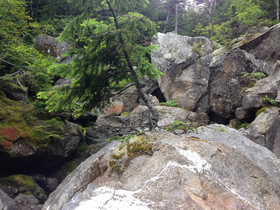
After our harrowing descent, we reached the sign marking the entrance to Mahoosuc Notch. So we tucked our poles in our packs, cracked our knuckles, and got down to business. It would be lots of rock scrambling on all fours. We were ready. We had been advised to take our time and try to have fun with it. This mile was not for time.
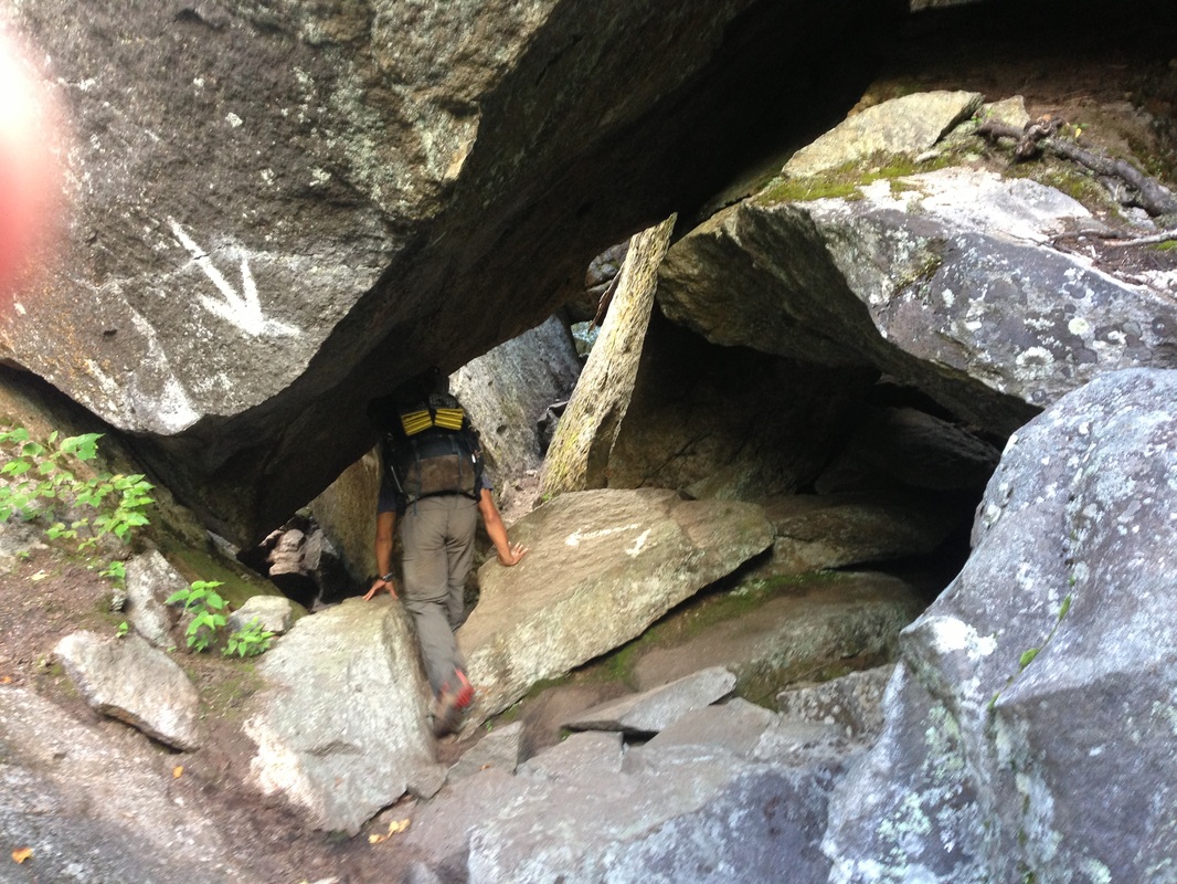
As it turned out, Mahoosuc Notch was lot of fun. There were tunnels to crawl through, gaps to squeeze through, obstacles to climb over, around , in between. There was no moose skeleton.
A few places we had to take our packs off and either push them ahead or pull them after us. A few places we had to try several different options before finding a route we could realistically complete. A few places I needed Subaru's help. But overall, it was like a giant playground that made you use your entire body and mind to get through. It was actually the funnest mile of the AT! It took us almost 2 hours to get through, but it was a fun 2 hours.
As we emerged on the other side of the notch, I felt a sense of relief. The hardest mile was over. It would be smooth sailing from here on out.
NOT.
Whoever named Mahoosuc Notch "the hardest mile of the AT" clearly had not completed the climb out, up Mahoosuc Arm. Mahoosuc Arm was a 1600 foot climb in 0.9 miles. On sheer rock face. It was like walking up a broken sidewalk on a 45 degree hill. For a mile. It was brutal. Every time we thought we were nearing the top, it just kept going. And going. And going. In places we were scrambling up tree roots. In other places, we were scrambling up the rock face on all fours. It put the notch to shame.
At the top, we ran into two more college orientation groups. I had found one boot around 3/4 the way up the arm. It was pretty new looking. I tied it to the back of my pack and was planning on putting it in the next shelter. But when we saw the college groups, I asked in my loudest voice: "Did anyone lose a boot?" I instantly became the most popular person on the mountain. So at least there was that. And nice views. Maine does have nice views.
After a bit of a descent, we came to Speck Pond Shelter where we stopped for lunch. If it had been about 10 degrees warmer, I would have swam in the pond all afternoon and stayed the night there. As it was, it was just a little too chilly for swimming. It was nice in the sun, but cool in the shade. Instead, as I ate my lunch, I looked at the guidebook and noticed that the hostels in Andover actually had shuttles that picked up at Grafton Notch, a mere 4.6 miles from the shelter. It would also allow us to knock off the 2.3 miles and 1200 feet of climbing to the next shelter.
At the top of Speck Mountain, the next climb after the shelter, we whipped out the cell phones and called The Cabin, a hostel in Andover. The Cabin was full, so we called Pine Ellis Lodging, the other hostel in Andover. Done! We were going to shower and sleep in beds tonight!
At the end of the day, we had gone 9.7 miles in 10 and a half hours. And I was more tired than I had been on any other day since starting. Maine had tried to kill me several times today, first with the boulders on the descent into the notch, then with the climb back out. Things had better get easier. Cause if the rest of Maine was like this, I would not make it to Katahdin!
Of course, in order to go into Mahoosuc Notch, we had to get there first. Which entailed a steep, rocky 1300 foot descent. No rebar or ladders here; just a jumble of tilted boulders with gaps in between that had me cursing all the way. Why couldn't I be just a couple inches taller? The AT was not designed with shorties in mind.
After our harrowing descent, we reached the sign marking the entrance to Mahoosuc Notch. So we tucked our poles in our packs, cracked our knuckles, and got down to business. It would be lots of rock scrambling on all fours. We were ready. We had been advised to take our time and try to have fun with it. This mile was not for time.
As it turned out, Mahoosuc Notch was lot of fun. There were tunnels to crawl through, gaps to squeeze through, obstacles to climb over, around , in between. There was no moose skeleton.
A few places we had to take our packs off and either push them ahead or pull them after us. A few places we had to try several different options before finding a route we could realistically complete. A few places I needed Subaru's help. But overall, it was like a giant playground that made you use your entire body and mind to get through. It was actually the funnest mile of the AT! It took us almost 2 hours to get through, but it was a fun 2 hours.
As we emerged on the other side of the notch, I felt a sense of relief. The hardest mile was over. It would be smooth sailing from here on out.
NOT.
Whoever named Mahoosuc Notch "the hardest mile of the AT" clearly had not completed the climb out, up Mahoosuc Arm. Mahoosuc Arm was a 1600 foot climb in 0.9 miles. On sheer rock face. It was like walking up a broken sidewalk on a 45 degree hill. For a mile. It was brutal. Every time we thought we were nearing the top, it just kept going. And going. And going. In places we were scrambling up tree roots. In other places, we were scrambling up the rock face on all fours. It put the notch to shame.
At the top, we ran into two more college orientation groups. I had found one boot around 3/4 the way up the arm. It was pretty new looking. I tied it to the back of my pack and was planning on putting it in the next shelter. But when we saw the college groups, I asked in my loudest voice: "Did anyone lose a boot?" I instantly became the most popular person on the mountain. So at least there was that. And nice views. Maine does have nice views.
After a bit of a descent, we came to Speck Pond Shelter where we stopped for lunch. If it had been about 10 degrees warmer, I would have swam in the pond all afternoon and stayed the night there. As it was, it was just a little too chilly for swimming. It was nice in the sun, but cool in the shade. Instead, as I ate my lunch, I looked at the guidebook and noticed that the hostels in Andover actually had shuttles that picked up at Grafton Notch, a mere 4.6 miles from the shelter. It would also allow us to knock off the 2.3 miles and 1200 feet of climbing to the next shelter.
At the top of Speck Mountain, the next climb after the shelter, we whipped out the cell phones and called The Cabin, a hostel in Andover. The Cabin was full, so we called Pine Ellis Lodging, the other hostel in Andover. Done! We were going to shower and sleep in beds tonight!
At the end of the day, we had gone 9.7 miles in 10 and a half hours. And I was more tired than I had been on any other day since starting. Maine had tried to kill me several times today, first with the boulders on the descent into the notch, then with the climb back out. Things had better get easier. Cause if the rest of Maine was like this, I would not make it to Katahdin!
 RSS Feed
